Contracts
Available Contracts, Master Service Agreements and Prequalifications
Surdex holds numerous government qualifications-based contracts to support engineering, transportation, agricultural and other programs. Vendors holding these contracts are thoroughly screened to ensure experience, competency and past performance. To see if your entity can operate a project under these contracts, contact the person listed.
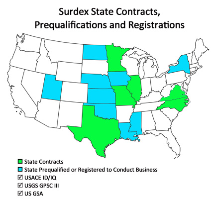
Federal Contracts:
- U.S. Army Corps of Engineers (USACE)
- U.S. Geological Survey Geospatial Products and Services Contract (USGS GPSC III)
- U.S. General Services Administration (GSA), Earth Observation Solutions
State Contracts:
- Texas Department of Information Resources (DIR) Co-op Contract Program
- Missouri Statewide Services Contract, Photogrammetric Mapping Products and Services
- Minnesota Cooperative Purchasing Venture (CPV) SWIFT Master Contract, Aerial Imagery
- Illinois DOT (IDOT)
- North Carolina DOT (NCDOT)
- State of Virginia Information Technologies Agency (VITA)
Surdex is also prequalified with numerous state Departments of Transportation that enable us to begin work on their projects immediately.
U.S. Army Corps of Engineers (USACE) IDIQ
Contract number: W912P920D0026
Surdex was awarded an Indefinite Delivery/Indefinite Quantity (IDIQ) Contract for surveying, mapping, and related services, through the St. Louis District. Federal entities can engage Surdex through this contract mechanism, with projects managed by the District.
Contact: Steve Kasten, Vice President Business Development – USACE
Office: (636) 368-4428
SteveK@surdex.com
U.S. Geological Survey Geospatial Products and Services Contract (USGS GPSC III)
Contract number: G16PC00029
The U.S. Geological Survey’s (USGS’s) Geospatial Products and Services Contract (GPSC) is a suite of contracts used by Federal, State, and municipal government entities to partner with the USGS to fulfill their geospatial data requirements.
The Merrick-Surdex Joint Venture (with Surdex and Merrick and Company) is one of only ten approved entities in the country under this contract.
Contact: Brett Thomassie, Vice President, Federal Business Development – Surdex Corporation
Office: (985) 718-7155
Brett.Thomassie@surdex.com
Kasey A. Brown, Director of Federal Programs – Merrick & Company
Office: (303) 353-3569
Cell: (256) 520-2772
Kasey.Brown@Merrick.com
http://www.merrick-surdexjv.com/MS_JV/
https://www.usgs.gov/core-science-systems/national-geospatial-program/geospatial-data-contracts
General Services Administration (GSA) Multiple Award Schedule Contract
Contract number: 47QTCA18D00J5
SIN: 132-41 Earth Observation Solutions
NAICS Code: 541370 Surveying and Mapping
GSA is contract and purchasing program that allows governments to leverage the buying power of the federal government.
GSA contracts were developed to assist federal employees in purchasing products and services; they contain pre-negotiated prices, delivery terms, warranties, and other terms and conditions which streamline the buying process. The program was expanded and offered to include state and municipal governments.
Visit the GSA Advantage! website to review catalog listings and to submit RFQs for services:
Contact: Tim Bohn, Vice President, Business Development
Office: (636) 368-4400
TimB@surdex.com
Texas Department of Information Resources (DIR) Contract
Co-op Contract Program
Contract number: DIR-TSO-3394
The State of Texas has a program for public entities to purchase technologies and solutions through a contract administered by the Department of Information Resources. This program enables eligible buyers to purchase geospatial products and customized geospatial services at discounted prices.
Additional information and pricing of geospatial data acquisitions, contact the Texas Natural Resources Information System (TNRIS) at StratMap@twdb.texas.gov.
https://www.texas-geospatial.com/
Contact: Cornell Rowan, Senior Project Manager
Office: (636) 368-4460
CornellR@surdex.com
Missouri Statewide Services Contract
Photogrammetric Mapping Products and Services
Contract number: CS170285002
Missouri BUYS System ID: MB00048428
This contract covers photogrammetric mapping products and services under the category of environmental, ecological and agricultural services. These typically include digital orthoimagery, lidar elevation data, and digital topographic and planimetric mapping. Agencies anticipated to utilize the contract (but not limited to) include: the Missouri Department of Conservation (MDC); Department of Natural Resources (DNR); Department of Transportation (MoDOT); State Emergency Management Agency (SEMA); and Department of Public Safety (DPS).
https://archive.oa.mo.gov/purch/contracts/
Contact: Jack King, Business Development
Office: (636) 368-4400
jack.king@surdex.com
Minnesota Cooperative Purchasing Venture (CPV)
Professional Services, Aerial Imagery
SWIFT Master Contract Number: 105113
The Minnesota CPV allows eligible Minnesota state agencies to purchase goods and professional services and utilities from contracts established by the Office of State Procurement (OSP) for Minnesota state agencies. OSP contracts with vendors to provide goods, services and utilities to state agencies. This program creates a legal relationship so that eligible governmental entities can use these contracts just like state agencies.
http://www.mmd.admin.state.mn.us/AerialImagery/Contractors.htm
Contact: Jack King, Business Development
Office: (636) 368-4400
jack.king@surdex.com